Friday, February 4, 2011

Bringing Ugly Back

In many ways, Australia is similar to the United States - style of dress, love of sports, driving culture, shopping culture, language (though my next post will include my running list of Australian - English translations).  And, for the most part, when I notice differences, they're reasonable.  With one important exception - the El Camino.  You remember the El Camino?  Of course you do.  The best thing about the El Camino is that it can bring people together in an unusual way - it's probably everyone's top-of-the-list ugliest car.  Apparently, this particular car aesthetic is a profound cultural divide.

Australia has brought ugly back.  

Now, it's not called the El Camino; but it is one.  And, I'm not talking about a bunch of old El Caminos driving around.  No.  Australia loves the El Camino so much that you can buy a new one - one that has actually been recently manufactured.  I'm serious.  Many of you won't believe me.  I've tried to get a photo of one, but by the time I get my camera ready, it has driven off.  This is now the top of my to-do list for my remaining days.
Check back in hopes of getting a sight of the newly resurrected Aussie version of the El Camino.

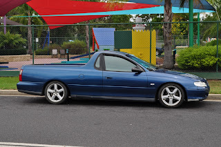
Addendum:  Ben and I went out and decided to snap some shots of El Caminos.  We limited the search to a single outing, during which we drove about 5 miles and saw an estimated 20 El Caminos.  Unfortunately, we saw most of them while we were driving and couldn't get a photo.  Though we did get two parked (photos below).  We missed photos of the best ones, including, but not limited to:  metallic mustard, canary yellow, chartreuse, black and gold, red white and blue (no, that's not a red one, a white one, and a blue one, I mean all three in one El Camino - it was fantastic), and the best - navy with yellow, orange, and red flames.


Wednesday, February 2, 2011

Queensland Can't Catch a Break

I decided to post a map.  Many people have asked me about the location of the recent flooding and now Cyclone Yasi.  On the map below, Queensland is the northeast part of Australia.  I have drawn an arrow approximating the path of Yasi (which has now headed inland through the interior, but as I write this, it has been downgraded to Category 2).  Also on the map is Brisbane, the most populated city in Queensland and 3rd largest in Australia (after Sydney then Melbourne).  Population about 2million.

Brief note on Yasi:  We watched a lot of the coverage on TV.  Facts change; these are the ones I am hearing now.  As Yasi hit northeastern Queensland, it was a Category 5 cyclone, winds about 270 k/hr.  News coverage is showing substantial damage following such a large cyclone (think about the post-Katrina photos).   But, Yasi is also leaving behind more flooding, which of course Queensland is not prepared to absorb (literally) as they haven't dried out from the flooding last month.  News coverage is saying that Yasi is the largest Cyclone to hit Australia.

So a brief note on the flooding:  I circled Brisbane on the map because much of the coverage was focused on Brisbane, which was hit very hard by the flooding.  But, a geographic reference that worked well for my mental map, was one that said the total area affected was as large as Germany and France, combined.  Most of the flooding was restricted to Queensland, though Victoria was also hit.  The worst natural disaster to ever hit Australia.

In true Aussie spirit, apparently it's the right time for a beer (last photo - taken post-Yasi).

Graphics below: map (basemap from Google Maps), Cyclone Yasi,  post-Yasi flooding, Brisbane flooding (from last month) - all photos from dailytelegraph.au.com